vtt à Bourgonce 26 juin 2016

vathi54
User
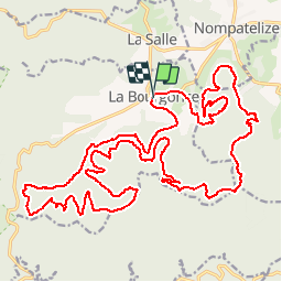

Length
31 km

Max alt
625 m

Uphill gradient
837 m
Km-Effort
42 km

Min alt
364 m

Downhill gradient
838 m
Boucle
Yes
Creation date :
2016-06-26 00:00:00.0
Updated on :
2016-06-26 00:00:00.0
3h39
Difficulty : Unknown

FREE GPS app for hiking
 SityTrail
IGN / Geographical institutes
SityTrail Plus
The world is yours!
About
Trail Mountain bike of 31 km to be discovered at Grand Est, Vosges, La Bourgonce. This trail is proposed by vathi54.
Positioning
Country:
France
Region :
Grand Est
Department/Province :
Vosges
Municipality :
La Bourgonce
Location:
Unknown
Start:(Dec)
Start:(UTM)
338926 ; 5353187 (32U) N.
Comments